Le score de décrépitude est calculé en prenant en compte plusieurs facteurs, avec une pondération
plus importante pour la différence de nombre de mots :
Facteur
Valeur
Poids
Contribution
Différence de date (en jours)
-337
20%
67.4
Différence de nombre de mots
1288
45%
6.44
Différence de nombre de sections
10
15%
1.5
Différence de nombre de liens
109
10%
1.64
Différence de nombre d'images
6
10%
0.12
Score total
77.1
Comment interpréter ce score :
Plus le score est élevé, plus la page française est considérée comme "décrépite" par rapport
à la version anglaise.
La différence de nombre de mots compte pour 50% du score, car c'est l'indicateur le plus
important de la complétude de la traduction.
Les différences de sections (15%), de liens (15%) et de date de modification (20%)
complètent le score.
== Contents ==
=== Personal tools ===
=== Namespaces ===
=== Views ===
=== Search ===
=== Site ===
=== Tools ===
=== In other projects ===
== Values == (EN only)
=== Approved === (EN only)
=== Other used === (EN only)
== Additional tags == (EN only)
=== Accessibility === (EN only)
=== Designation === (EN only)
=== Mode of transport === (EN only)
==== Support ==== (EN only)
=== Traffic signals === (EN only)
=== Other features === (EN only)
== Examples == (EN only)
== Tagging crossings as ways == (EN only)
== See also == (EN only)
== External links == (EN only)
== References == (EN only)
=== In other languages === (EN only)
v - https://wiki.openstreetmap.org/wiki/Template:KeyDescription
d - https://wiki.openstreetmap.org/wiki/Template_talk:KeyDescription
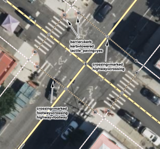
highway - https://wiki.openstreetmap.org/wiki/Key:highway
crossing - https://wiki.openstreetmap.org/wiki/Tag:highway%3Dcrossing
railway - https://wiki.openstreetmap.org/wiki/Key:railway
footway - https://wiki.openstreetmap.org/wiki/Tag:highway%3Dfootway
cycleway - https://wiki.openstreetmap.org/wiki/Tag:highway%3Dcycleway
path - https://wiki.openstreetmap.org/wiki/Key:path
crossing:markings - https://wiki.openstreetmap.org/wiki/Key:crossing:markings
tactile_paving - https://wiki.openstreetmap.org/wiki/Key:tactile_paving
crossing:island - https://wiki.openstreetmap.org/wiki/Key:crossing:island
flashing_lights - https://wiki.openstreetmap.org/wiki/Key:flashing_lights
kerb - https://wiki.openstreetmap.org/wiki/Key:kerb
supervised - https://wiki.openstreetmap.org/wiki/Key:supervised
lit - https://wiki.openstreetmap.org/wiki/Key:lit
wheelchair - https://wiki.openstreetmap.org/wiki/Key:wheelchair
More details at taginfo - https://taginfo.openstreetmap.org/keys/crossing
taginfo - https://wiki.openstreetmap.org//taginfo.openstreetmap.org/keys/crossing
AD - https://taginfo.geofabrik.de/europe/andorra/keys/crossing
AT - https://taginfo.geofabrik.de/europe/austria/keys/crossing
BR - https://taginfo.geofabrik.de/south-america/brazil/keys/crossing
BY - https://taginfo.geofabrik.de/europe/belarus/keys/crossing
CH - https://wiki.openstreetmap.org//taginfo.osm.ch/keys/crossing
CN - https://taginfo.geofabrik.de/asia/china/keys/crossing
CZ - http://taginfo.openstreetmap.cz/keys/crossing
DE - https://taginfo.geofabrik.de/europe/germany/keys/crossing
DK - https://taginfo.geofabrik.de/europe/denmark/keys/crossing
FI - https://taginfo.geofabrik.de/europe/finland/keys/crossing
FR - https://wiki.openstreetmap.org//taginfo.openstreetmap.fr/keys/crossing
GB - http://taginfo.openstreetmap.org.uk/keys/crossing
GR - https://taginfo.geofabrik.de/europe/greece/keys/crossing
HU - http://taginfo.openstreetmap.hu/keys/crossing
IN - https://wiki.openstreetmap.org//taginfo.openstreetmap.in/keys/crossing
IR - https://taginfo.geofabrik.de/asia/iran/keys/crossing
IT - https://taginfo.geofabrik.de/europe/italy/keys/crossing
LI - https://taginfo.geofabrik.de/europe/liechtenstein/keys/crossing
LU - https://taginfo.geofabrik.de/europe/luxembourg/keys/crossing
JP - https://taginfo.openstreetmap.jp/keys/crossing
KP - https://taginfo.geofabrik.de/asia/north-korea/keys/crossing
KR - https://taginfo.geofabrik.de/asia/south-korea/keys/crossing
NL - https://taginfo.geofabrik.de/europe/netherlands/keys/crossing
PL - http://taginfo.openstreetmap.pl/keys/crossing
PT - https://taginfo.geofabrik.de/europe/portugal/keys/crossing
RU - https://taginfo.geofabrik.de/russia/keys/crossing
ES - https://wiki.openstreetmap.org//taginfo.geofabrik.de/europe/spain/keys/crossing
AR - https://wiki.openstreetmap.org//taginfo.geofabrik.de/south-america/argentina/keys/crossing
MX - https://wiki.openstreetmap.org//taginfo.geofabrik.de/north-america/mexico/keys/crossing
CO - https://wiki.openstreetmap.org//taginfo.geofabrik.de/south-america/colombia/keys/crossing
BO - https://wiki.openstreetmap.org//taginfo.geofabrik.de/south-america/bolivia/keys/crossing
CL - https://wiki.openstreetmap.org//taginfo.geofabrik.de/south-america/chile/keys/crossing
EC - https://wiki.openstreetmap.org//taginfo.geofabrik.de/south-america/ecuador/keys/crossing
PY - https://wiki.openstreetmap.org//taginfo.geofabrik.de/south-america/paraguay/keys/crossing
PE - https://wiki.openstreetmap.org//taginfo.geofabrik.de/south-america/peru/keys/crossing
UY - https://wiki.openstreetmap.org//taginfo.geofabrik.de/south-america/uruguay/keys/crossing
VE - https://wiki.openstreetmap.org//taginfo.geofabrik.de/south-america/venezuela/keys/crossing
TW - https://taginfo.geofabrik.de/asia/taiwan/keys/crossing
UA - https://taginfo.geofabrik.de/europe/ukraine/keys/crossing
US - https://taginfo.geofabrik.de/north-america/us/keys/crossing
VN - https://taginfo.geofabrik.de/asia/vietnam/keys/crossing
overpass-turbo - https://overpass-turbo.eu/?template=key&key=crossing
OSM Tag History - https://taghistory.raifer.tech/#***/crossing/
traffic_signals - https://wiki.openstreetmap.org/wiki/Tag:highway%3Dtraffic_signals
uncontrolled - https://wiki.openstreetmap.org/wiki/Tag:crossing%3Duncontrolled
unmarked - https://wiki.openstreetmap.org/wiki/Tag:crossing%3Dunmarked
no - https://wiki.openstreetmap.org/wiki/Tag:crossing%3Dno
island - https://wiki.openstreetmap.org/wiki/Tag:crossing%3Disland
bicycle - https://wiki.openstreetmap.org/wiki/Key:bicycle
horse - https://wiki.openstreetmap.org/wiki/Key:horse
segregated - https://wiki.openstreetmap.org/wiki/Key:segregated
button_operated - https://wiki.openstreetmap.org/wiki/Key:button_operated
traffic_signals:sound - https://wiki.openstreetmap.org/wiki/Key:traffic_signals:sound
traffic_signals:vibration - https://wiki.openstreetmap.org/wiki/Key:traffic_signals:vibration
traffic_signals:arrow - https://wiki.openstreetmap.org/wiki/Key:traffic_signals:arrow
traffic_signals:minimap - https://wiki.openstreetmap.org/wiki/Key:traffic_signals:minimap
yes - https://wiki.openstreetmap.org/wiki/Tag:supervised%3Dyes
Approved features/Road crossings - https://wiki.openstreetmap.org/wiki/Special:PermanentLink/132309
crossings - https://wiki.openstreetmap.org/wiki/Category:Crossings (EN only)
elements - https://wiki.openstreetmap.org/wiki/Elements (EN only)
9 - https://wiki.openstreetmap.org/wiki/Category:Tag_descriptions_for_key_%22crossing%22 (EN only)
crossing:continuous - https://wiki.openstreetmap.org/wiki/Key:crossing:continuous (EN only)
crossing_ref - https://wiki.openstreetmap.org/wiki/Key:crossing_ref (EN only)
Status: - https://wiki.openstreetmap.org/wiki/Tag_status#Status_values (EN only)
1Values - #Values (EN only)
1.1Approved - #Approved (EN only)
1.2Other used - #Other_used (EN only)
2Additional tags - #Additional_tags (EN only)
2.1Accessibility - #Accessibility (EN only)
2.2Designation - #Designation (EN only)
2.3Mode of transport - #Mode_of_transport (EN only)
2.3.1Support - #Support (EN only)
2.4Traffic signals - #Traffic_signals (EN only)
2.5Other features - #Other_features (EN only)
3Examples - #Examples (EN only)
4Tagging crossings as ways - #Tagging_crossings_as_ways (EN only)
5See also - #See_also (EN only)
6External links - #External_links (EN only)
7References - #References (EN only)
marked - https://wiki.openstreetmap.org/wiki/Tag:crossing%3Dmarked (EN only)
zebra - https://wiki.openstreetmap.org/wiki/Tag:crossing_ref%3Dzebra (EN only)
[1] - #cite_note-1 (EN only)
traffic_island - https://wiki.openstreetmap.org/wiki/Tag:footway%3Dtraffic_island (EN only)
informal - https://wiki.openstreetmap.org/wiki/Tag:crossing%3Dinformal (EN only)
§ Traffic signals - #Traffic_signals (EN only)
barrier - https://wiki.openstreetmap.org/wiki/Key:barrier (EN only)
boolean - https://en.wikipedia.org/wiki/en:Boolean_data_type (EN only)
routers - https://wiki.openstreetmap.org/wiki/Routers (EN only)
crossing:signals - https://wiki.openstreetmap.org/wiki/Key:crossing:signals (EN only)
Crossing guard - https://en.wikipedia.org/wiki/Crossing_guard (EN only)
Zebra crossing - https://en.wikipedia.org/wiki/Zebra_crossing (EN only)
Pelican crossing - https://en.wikipedia.org/wiki/Pelican_crossing (EN only)
pelican - https://wiki.openstreetmap.org/wiki/Tag:crossing_ref%3Dpelican (EN only)
Tiger crossing - https://en.wikipedia.org/wiki/Zebra_crossing#Tiger_and_parallel_crossings (EN only)
Toucan crossing - https://en.wikipedia.org/wiki/Toucan_crossing (EN only)
Pegasus crossing - https://en.wikipedia.org/wiki/Pegasus_crossing (EN only)
definition in Ontario rule book - http://www.mto.gov.on.ca/english/safety/pedestrian-safety.shtml (EN only)
flush - https://wiki.openstreetmap.org/wiki/Tag:kerb%3Dflush (EN only)
multiple values - https://wiki.openstreetmap.org/wiki/FAQ#What_shall_I_do_for_roads_that_have_multiple_values_for_a_tag? (EN only)
give_way - https://wiki.openstreetmap.org/wiki/Tag:highway%3Dgive_way (EN only)
stop - https://wiki.openstreetmap.org/wiki/Tag:highway%3Dstop (EN only)
Cycle routes - https://wiki.openstreetmap.org/wiki/Cycle_routes (EN only)
Proposed features/Traffic island - https://wiki.openstreetmap.org/wiki/Proposed_features/Traffic_island (EN only)
Proposed features/crossing=marked - https://wiki.openstreetmap.org/wiki/Proposed_features/crossing%3Dmarked (EN only)
Proposed features/Unambiguous crossings - https://wiki.openstreetmap.org/wiki/Proposed_features/Unambiguous_crossings (EN only)
Proposed_features/Highway_crossing_cleanup - https://wiki.openstreetmap.org/wiki/Proposed_features/Highway_crossing_cleanup (EN only)
Pedestrian crossing - https://en.wikipedia.org/wiki/en:Pedestrian_crossing (EN only)
Crosswalks - San Francisco Better Streets - https://www.sfbetterstreets.org/find-project-types/pedestrian-safety-and-traffic-calming/crosswalks/ (EN only)
↑ - #cite_ref-1 (EN only)
https://github.com/westnordost/StreetComplete/issues/495 - https://github.com/westnordost/StreetComplete/issues/495 (EN only)
https://wiki.openstreetmap.org/w/index.php?title=Key:crossing&oldid=2666133 - https://wiki.openstreetmap.org/w/index.php?title=Key:crossing&oldid=2666133 (EN only)
== Contents ==
=== Personal tools ===
=== Namespaces ===
=== Views ===
=== Search ===
=== Site ===
=== Tools ===
=== In other projects ===
== L'attribut «crossing » == (FR only)
== Attributs supplémentaires == (FR only)
== Exemples == (FR only)
== Marquage des passages en tant que routes == (FR only)
== Voir aussi == (FR only)
== Liens externes == (FR only)
== Values == (EN only)
=== Approved === (EN only)
=== Other used === (EN only)
== Additional tags == (EN only)
=== Accessibility === (EN only)
=== Designation === (EN only)
=== Mode of transport === (EN only)
==== Support ==== (EN only)
=== Traffic signals === (EN only)
=== Other features === (EN only)
== Examples == (EN only)
== Tagging crossings as ways == (EN only)
== See also == (EN only)
== External links == (EN only)
== References == (EN only)
=== In other languages === (EN only)
== L'attribut «crossing » == (FR only)
== Attributs supplémentaires == (FR only)
== Exemples == (FR only)
== Marquage des passages en tant que routes == (FR only)
== Voir aussi == (FR only)
== Liens externes == (FR only)